


توضیحات MapTiler Mobile
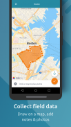
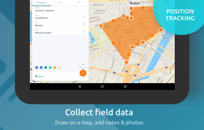
See your GPS position on your own maps. Draw points, polygons and lines on the maps. Collect field data and notes related to a location, attach a photo and fill custom properties.
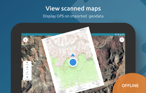
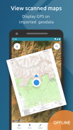
Display offline maps generated with MapTiler (https://www.maptiler.com).
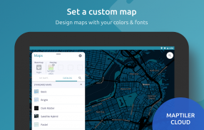
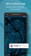
Choose from various basemaps like street and satellite. Preview on a mobile device the map you previously designed with own colors and fonts in MapTiler Cloud.
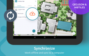
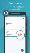
The app supports GeoJSON and MBTiles formats and data synchronization between multiple devices and desktop computer using cloud. I it easy to share the data with other people and collaborate! Perfect for mobile data collection for GIS and surveys.
Import scanned hiking maps, PDF maps, drone aerial imagery, nautical charts for sailing and navigation with a boat or a yacht, fishing maps, aeronautical charts for flight planning by pilots, parcels and city plans and other opendata from local government. OpenStreetMap vector maps are powered by OpenMapTiles project (the successor of OSM2VectorTiles). Maps can come from existing tile servers with OGC WMTS, TileJSON or XYZ tiles from.
Supported geodata formats by MapTiler: GeoTIFF, TIFF, JPEG, ECW, SID / MrSID, NOAA KAP / BSB, DEM, OziExplorer OZI OZF2 & OZFX3, WebP, JP2, JPEG2000, GeoJP2, Erdas, Grass, Safe, Sentinel2, SRTM, NASA imagery, USGS map sheets, exports from ESRI ArcGIS, ArcSDE, etc.
The GeoJSON can be converted from / to: ESRI ShapeFile (SHP), DXF, DWG, GPX, CSV and KML.
موقعیت GPS خود را در نقشه های خود مشاهده کنید. نقاط ، چند ضلعی و خط را بر روی نقشه بکشید. جمع آوری داده ها و یادداشت های مربوط به یک مکان ، پیوست یک عکس و پر کردن ویژگی های سفارشی.
نقشه های آفلاین تولید شده با MapTiler (https://www.maptiler.com) را نمایش دهید.
از بین نقشه های اصلی مانند خیابان و ماهواره را انتخاب کنید. پیش نمایش در دستگاه تلفن همراه نقشه ای را که قبلاً با رنگ ها و قلم های خاص خود در MapTiler Cloud طراحی کرده باشید.
برنامه از قالب های GeoJSON و MBTiles و همگام سازی داده ها بین دستگاه های مختلف و رایانه رومیزی با استفاده از cloud پشتیبانی می کند. من به راحتی به اشتراک گذاری داده ها با افراد دیگر و همکاری می پردازم! ایده آل برای جمع آوری داده های تلفن همراه برای GIS و نظرسنجی ها.
واردات نقشه های پیاده روی اسکن شده ، نقشه های PDF ، تصاویر هوایی بدون سرنشین ، نمودارهای دریایی برای قایقرانی و پیمایش با یک قایق یا قایق بادبانی ، نقشه های ماهیگیری ، نمودارهای هوایی برای برنامه ریزی پرواز توسط خلبانان ، بسته ها و نقشه های شهر و سایر اپتدا های دولت محلی. نقشه های برداری OpenStreetMap توسط پروژه OpenMapTiles (جانشین OSM2VectorTiles) پشتیبانی می شوند. نقشه ها می توانند از سرورهای کاشی موجود با کاشی OGC WMTS ، TileJSON یا XYZ از آنجا تهیه شوند.
قالبهای ژئوداتا پشتیبانی شده توسط MapTiler: GeoTIFF، TIFF، JPEG، ECW، SID / MrSID، NOAA KAP / BSB، DEM، OziExplorer OZI OZF2 & OZFX3، WebP، JP2، JPEG2000، GeoJP2، Erdas، Grass، SAS، SAS تصاویر ، برگه های نقشه USGS ، صادرات از ESRI ArcGIS ، ArcSDE و غیره
GeoJSON را می توان از / به: ESRI ShapeFile (SHP) ، DXF ، DWG ، GPX ، CSV و KML تبدیل کرد.
MapTiler Mobile - نسخه 2.0.1
(12-03-2020)MapTiler Mobile - اطلاعات APK
نسخه APK: 2.0.1حزمة: com.maptiler.geoeditorاپلیکیشنها در دسته مشابه
شاید دوست داشته باشید...


